As-built surveys.
No return visits.
One scan gives your practice millimetre-accurate point clouds, BIM-ready geometry and precise floor plans — everything needed to start design without setting foot on site again.

Traditional surveys slow your practice down.
- ✕Multiple site visits to remeasure missed details
- ✕Inaccurate hand measurements causing design errors
- ✕No visual reference once back in the studio
- ✕Expensive change orders from incorrect as-built data
- ✕Hard to collaborate remotely with clients or consultants
One scan. Everything you need.
- Millimetre-accurate E57 point cloud for Revit or AutoCAD
- Navigate the space virtually from your studio, any time
- Auto-generated floor plans with precise square metres
- Shareable 3D tour for client presentations and design reviews
- Delivered within 24 hours of the on-site capture
Where practices use it most.
From a single-room refurb to a full building survey — here's how architects and interior designers across the South West are putting 3D scanning to work.

Start design with confidence.
Capture the exact as-built state of any space — dimensions, ceiling heights, structural elements, services. Import into BIM or CAD and begin designing without guesswork.
Brief contractors with total clarity.
Share a navigable 3D model of the existing space with your contractor before works begin. Every trade can walk the site remotely and price more accurately.

Document every detail, permanently.
The South West is rich in listed buildings. A 3D scan creates a permanent, millimetre-accurate record of the existing fabric — invaluable for planning applications and conservation statements.
Every file your practice needs.
A single scan produces a complete set of deliverables — formatted for the tools your team already uses.
E57 Point Cloud
High-density LiDAR point cloud in the industry-standard E57 format. Import directly into Revit, AutoCAD, Rhino, Navisworks or ReCap.
2D Floor Plans
Auto-generated schematic floor plans with dimensions and area calculations. Ready for planning applications, client presentations and contractor briefs.
3D Walkthrough Tour
Hosted navigable Matterport digital twin. Share with clients for design review, brief contractors remotely, or use for planning presentations.
360° Panoramic Images
High-resolution panoramas from every scan position — useful for client mood boards, planning documentation and condition records.
OBJ Mesh (Professional+)
Textured 3D mesh in OBJ format for SketchUp, 3ds Max or Rhino — useful for visualisation, massing studies and 3D presentation.
Schematic floor plans on every scan
Auto-generated 2D floor plans with dimensioned layouts and total area calculations included with every scan — no extra step, no extra cost. DWG-ready for import into CAD on Professional tier.
Camera Specification
Matterport Pro3
Pro3 is Matterport's most accurate camera — the same equipment used by leading AEC practices worldwide.
From site to Revit, without the back-and-forth.
Here's how a typical existing condition survey works — from first contact to files in your model.
Send us the brief
Share the address, floor area and outputs needed. We confirm the quote and schedule same day.
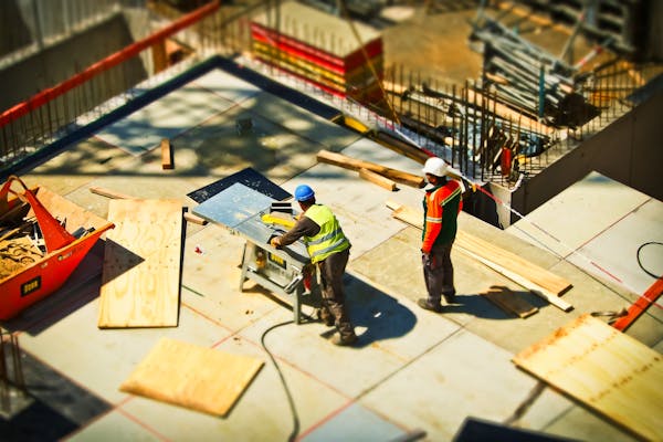
We capture the site
Matterport Pro3 on site. Systematic scan pattern for full coverage — no gaps, no missed corners. Typically 2–4 hours.
You receive the files
E57 point cloud, floor plans, hosted tour link and all formats — within 24 hours in a single organised delivery.
Import and start designing
Load E57 into Revit or AutoCAD and begin tracing. Share the hosted tour with clients or consultants.

Works with the tools you already use.
E57 and LAS exports compatible with all major AEC platforms — no conversion, no plugins.
Autodesk Revit
Import E57 directly as a point cloud overlay
AutoCAD
RCP/RCS point cloud — trace floor plans with precision
Rhino 3D
Import E57 for massing studies and detailed modelling
Navisworks
Clash detection and project coordination
ReCap Pro
Autodesk's dedicated point cloud processing environment
The 3D model your clients will navigate.
Every scan includes a hosted 3D tour — share with clients, use in presentations, or brief contractors remotely.
Drag to navigate · switch to dollhouse or floor plan · use measurement tool for dimensions
Brief to delivery in 48 hours.
A simple process that fits around your project programme.
Send a Brief
Address, area, required outputs. Quoted and scheduled within 24 hours.
Site Capture
Full Pro3 scan. Systematic coverage. 2–4 hours on site.
Process & Package
Point cloud, floor plans, tour and all formats QA'd and packaged.
Files Delivered
All deliverables in a single transfer — within 24 hours of capture.
Numbers that back it up.
Industry research on how 3D scanning transforms AEC workflows.
Matterport AEC
"We eliminated the reliance on measuring tapes and the need for return site visits."
AEC teams using Matterport consistently report faster as-built documentation, fewer site visits and more accurate BIM inputs. The Pro3 captures a position in under 20 seconds. Point cloud exports (E57/XYZ) integrate directly with Autodesk Revit via Matterport's free plug-in — removing manual measurement from the process entirely.
Source: Matterport AEC platform documentationWhy it matters for condition surveys
A timestamped, navigable record every stakeholder can access remotely.
Traditional condition surveys become outdated the moment work starts. A Matterport scan creates a permanent, measurable 3D record of existing conditions — one every team member can navigate, annotate and measure within, without travelling to site. For renovation and heritage projects, that's not a convenience — it's the difference between accurate and estimated.
RealityLayer analysis · Matterport AEC dataPriced for practice budgets.
Every scan includes a hosted 3D tour as standard. Point cloud and BIM exports from Professional tier.
Standard
scan fee · first month free
then £25 / month hosting
- Up to 250 sqm
- Full Matterport 3D tour
- Auto floor plan & dimensions
- Permanent hosted URL
- Shareable link & embed code
- First month hosting included
Professional
one-time scan fee
+ £39 / month hosting
- Up to 1,000 sqm
- Full Matterport 3D tour
- 10 professional site photos
- Shareable link & embed code
- Auto floor plan & dimensions
- Point cloud extraction ready (E57 / XYZ)
- First month hosting included
Enterprise
Large format & multi-site
- Unlimited floor area
- Multi-building projects
- Construction progress tracking
- Scheduled re-scan packages
- Dedicated account manager
Point cloud exports from Professional. Hosting always included on every plan.
Photography add-on available
Already included in Professional plans. Add 10 edited hero shots to any Standard scan for +£75 — one visit, everything done.
Ready to eliminate the return visit?
We work with architects and interior designers across Exeter, East Devon and the wider South West. Same-day quotes.
Thanks for getting in touch. We'll come back to you at hello@realitylayer.co.uk within a few hours.